Garmin are renowned as the World’s leading GPS and Sat Nav company, so it’s a surprise that it’s taken them so long to create their own GPS iPhone application – but that time has now come, and I’ve managed to put together a review of Garmin StreetPilot. The Garmin StreetPilot iPhone app is available to purchase direct from the iTunes Store, so please take the time to read my review – there’s a link to purchase at the end of the page.

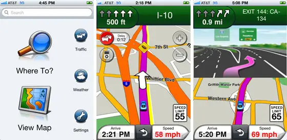
Being a Garmin GPS application you would expect it to be accurate, and it delivers on that promise. It’s has loads of great Garmin navigation features included in it that you will recognise from their standard Nuvi GPS models if you already own one of those. It is the first iPhone GPS navigation app to include PhotoReal images of complicated junctions which should help you to navigate safely and securely.
Easy and Clear to Read Mapping
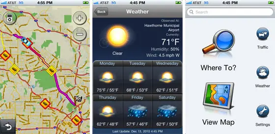
The maps on the screen are very clear. In fact they are almost identical to the best-selling Nuvi range which are generally very simple to use, winning awards for their design and usability. The Maps included offer you full coverage of North America plus now the United Kingdom and Ireland. As you can see from the screenshots taken below, the icons are large and clear and the maps represent the junctions and roads very clearly.
Contains Millions of POIs Including Gas Stations
POIs (otherwise known as Points of Interest files) are great for helping you to find something on your route. So whether that’s a restaurant, gas station, golf course, ATM, or tourist attraction – your POIs will display on the screen as you drive – plus contain detailed information on each point. It’s great for long journeys and vacations.

StreetPilot’s Turn by Turn Directions on the iPhone
When driving to your destination you will benefit from clearly spoken turn by turn directions. Your iPhone will speak out the street names and directions for you meaning that you can keep your eyes on the road ahead but still navigate accurately via the GPS on your Apple iPhone StreetPilot App. The voice could probably be clearer, but then the speaker on the iPhone isn’t the best on the market so I have to lay some blame on the hardware for that small issue. Having said that, the Garmin App does seem to handle mapping a lot better than the rival TomTom iPhone app.
Real-Time Traffic Alerts on StreetPilot
This Garmin app for iPhone comes with real-time traffic alerts which you don’t need to pay subscription fees for. If you look at the screenshots from the Garmin iPhone app below you will see how the traffic alerts present themselves. They are easy to understand and read and can offer you valuable travel time if you then opt to choose a different route via the simple and intuitive user-interface.

Map Coverage on the Garmin iPhone App
As I mentioned, the mapping included will cover the whole of North America, and just like Garmin’s traditional GPS Nuvi devices, the maps are loaded onto the iPhone itself. This was a nice surprise as I wasn’t sure that the iPhone would be able to handle this size of file download due to the amount of hard drive space available on the device.
This means that you will have GPS navigation even when there is no cell coverage available – so even with no access to 3G should will be able to still use the iPhone StreetPilot application – and could even buy Garmin map updates for it in the future perhaps?
Conclusion on the StreetPilot Garmin iPhone App Review
Generally it’s a bargain offering from the World’s leading navigation company and can be purchased from the iTunes Store for under fifty dollars. Given that Garmin Nuvi GPS devices are hard to find for under one hundred dollars this is a real bargain for users of the iPhone. You won’t get as many features as you would on a Nuvi, but for a budget prices it’s a decent product that stands up very well when compared to the competition of TomTom and Navigon who both have iPhone apps available.

